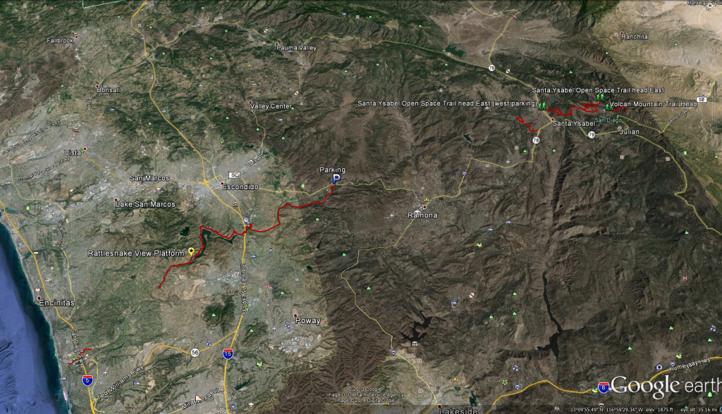
The Coast to Crest trail is part of a restoration project that is ongoing in San Diego. When finished the trail will stretch 70 miles from the beaches in Del Mar to Volcan Mountain, the source of water for the Santa Ysabel Creek that begins at the Ironsides Springs on the west side of the mountain and flows down to the San Pasqual Valley.
The Trail is only made up of segments at this point. The trail starts in Del Mar just west of the Del Mar Race Track and runs along the new restored San Diegito Lagons to the horse park where it stops for now. The Trail picks up again deep in Rancho Santa Fe just west of the Crosby Estates and runs along Del Dios Gorge to meet up with the trails that skirt the north shore of Lake hodges. The trail goes under the 15 freeway and connects up with the Mule Hill / San Pasqual Trails work its way east and stopping about 2 miles east of the Wild Animal Park. The trail then picks up again in Santa Ysabel working its way up to Volcan Mountain.
The largest continuous section of the trail open at this time runs 23 miles from just east of the Crosby Estates to just west of the San Diego Wild Animal Park.
The trails that are part of the Coast to Crest are as follows: From West to East
Crest Canyon Open Space: I’m not sure why this is part of the coast to crest trail as it does not run west to east but I do have clients that run on this trail daily and really like it.
Distance:1.15 miles 1-way : Elevation Gain:249feet: Trail Difficulty: Easy/Moderate: Dogs are allowed on Leash: Hiking only.
Directions to Trail: Take I-5 north to Via de la Valle. Go west on Via de la Valle, then south on Jimmy Durante Blvd., turn left on San Dieguito Drive just past the bridge over the San Dieguito River. Drive about .6 mile to kiosk.Park on side of road.
Distance: .25miles 1-way : Elevation Gain: Flat: Trail Difficulty: Easy: Dogs are allowed on Leash: Hiking only.
Directions to Trail: Take I-5 north to Via de la Valle. Go west on Via de la Valle, then south on Jimmy Durante Blvd. Just past the bridge over the San Dieguito River. The trail is located along the south shore of the river, west of Jimmy Durante Blvd.
Distance: 2 miles 1-way : Elevation Gain: Flat: Trail Difficulty: Easy: Dogs are allowed on Leash: Hiking only.
Trailhead location: Take I-5 north to Via de la Valle. Option 1: Go west on Via de la Valle, then south on Jimmy Durante Blvd. Just past the bridge over the San Dieguito River, take a right where the Del Mar Public Works Yard is located. Park where you can find a legal space. This is the closest access to the west end. From the parking area, cross Jimmy Durante Blvd., then cross the bridge to the north side of the river. Trail is on the east. Option 2: Go east on Via de la Valle, turn right on San Andres. Park anywhere along San Andres. Access trail at kiosk.
